

Built Heritage Workshop in Zanzibar
Drashti Nakrani • November 2026

East African heritage professionals learning to record the layered fabric of a town: from analogue notes to photogrammetric models.
 |
 |
 |
 |
 |
From 10th to 14th April 2026, we held a built heritage workshop in the Stone Town of Zanzibar, Tanzania. The workshop was attended by participants from the MAEASaM Project, the National Museum of Kenya (NMK), the National Museum of Tanzania (NMT) , the Department of Museums and Antiquities, Zanzibar (DOMA), and Heritage Watch Ethiopia (HWE). The aim of the workshop was to discuss the need and purpose of the MAEASaM built heritage database and demonstrate the digital recording practices for built heritage such as photography and photogrammetry.
Built Heritage refers to immovable man-made structures that hold historical, architectural, social, or cultural significance in a region. This can include standing ruins, traditional houses, defence buildings, religious sites, and institutional structures. In Zanzibar’s Stone Town, Built Heritage encompasses a range of buildings, from the House of Wonders (the landmark largest and tallest building of Stone Town) to houses constructed from local materials like coral stone, and featuring extraordinary carved wooden elements. These carvings, including intricate doors, reflect the exchanges of architectural styles, trade, and power throughout history.
Zanzibar Stone Town is situated by the sea and is characterised by narrow alleys that can easily disorient visitors. Having walked the streets of the old city of Ahmedabad, Gujarat (India) as a student, I noticed similarities in the architecture and the urban fabric in the Stone Town of Zanzibar, despite differences in climate and local cultures. It’s interesting how trade interactions have influenced and shaped the architectural landscape of Zanzibar.
– Drashti Nakrani
 |
Hands-on recording at the Maruhubi ruinsWe kicked off the workshop by diving into the hands-on session of recording techniques for built heritage. Dividing into groups of four, participants explored the ruins and captured the ruins in a systematic manner from contextual setting, condition, and details using a mix of analogue (sketch plan and elevations) and digital photography. The day ended with a demonstration of the terrestrial photogrammetry using an android tablet device. Photograph: Participants engaging in hands-on practice for photographic documentation of the ruins. Credit: Drashti Nakrani. |
 |
Why a built heritage database?Day two focused on the bigger picture — the idea of a shared built heritage database. Partners shared their recording practices, which led to an open discussion about what such a database should include and why we need it. The discussion regarding the database opened up conversations about accessibility, interoperability, and sharing. Day two ended with a group exercise on what the database could include if tailored for monitoring/conservation, documentation, education, and tourism. Photograph: Philip Maligisu from NMT presenting the recording practices followed at the organisation. Credit: Drashti Nakrani. |

|
From photos to a 3D modelWe walked through the process of building a photogrammetric 3D model of one of the walls of Maruhubi Palace using photographs captured on day one in the open-source software Meshroom, followed by visualisation of the model and extraction of a 2D ortho image from the 3D model in the open-source software MeshLab. Georeferencing of archival maps onto present-day satellite imagery in QGIS was also demonstrated. The idea behind this exercise was to make the team aware of photogrammetric processes and how they can use this data. Photograph: Video of the process of data collection to data processing to generating an ortho image. Credit: Drashti Nakrani and Mwamvita Sollo. |
 |
KOBO CollectAnother day of onsite data collection across the Stone Town — this time using KOBO Collect forms to build a photographic glossary of building elements, conditions, and materials in two languages, Swahili and English. The team engaged with selected buildings in the Stone Town to record the elements, conditions, and materials. The main finding from this exercise is that a photographic glossary can help identify architectural elements. In Swahili, doors are called “Mlango,” and arches, brackets, and railings are called “Nakshi.” However, some architectural elements do not have specific Swahili names. Photograph: Participants recording the data for photographic glossary using KOBO Collect form at the Old Fort in Zanzibar. Credit: Drashti Nakrani. |
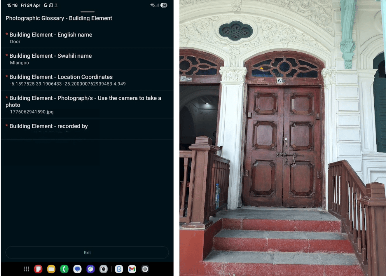 |
Closing with the Department of AntiquitiesThe final day was a working session with the Department of Antiquities in Zanzibar to understand what they need from a built heritage database and to demonstrate how to fill in metadata for captured images. Photograph: KOBO Collect form used for collecting data for photographic glossary of building elements. Credit: Drashti Nakrani. |
Acknowledgements: Thank you to our collaborators from NMT, NMK, DOMA – Zanzibar, and Heritage Watch Ethiopia for attending and participating in the workshop and sharing their thoughts and experiences.
Facilitated by: Kei Abdalla and Ally Ussi from DOMA, Zanzibar, with the logistical arrangements for the workshop; Stephanie Wynne-Jones and Drashti Nakrani from the University of York, UK; and Stefania Merlo from the University of Cambridge, UK.
Research Associate at the University of York